Predicting Flooding Risk for Pan-European REIT Assets using Local Features
- 97%
- accuracy reproducing the simulated yes/no 20-year flood label
- ~45,700
- sampled locations
- 33
- local features
- 73.8%
- accuracy on four risk classes
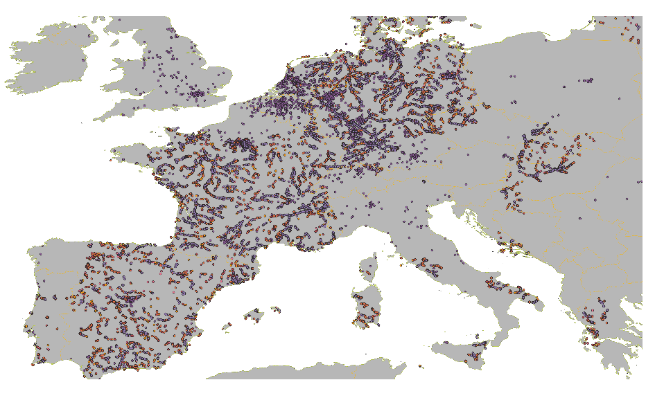
The standard pan-European fluvial flood hazard maps come from a 2D hydrodynamic simulation: accurate, but neither explainable nor adaptable. This BSc thesis (Artificial Intelligence, University of Amsterdam, 2022; industry partner KR&A) asks whether those simulated flood-return-period labels can be reproduced from local, interpretable features of a location. Thirty-three features across micro, meso and macro scales (precipitation extremes, ground type, artificial imperviousness at multiple radii, distance and relative height to the nearest river, terrain depressions, regional economics) are extracted for ~45,700 balanced samples: flooded points around all European towns above 1,000 inhabitants, no-flood points from a separate sample of KR&A assets. A Random Forest reproduces the binary 20-year flood label at 97% accuracy and four ordered risk classes at 73.8%, with surrounding imperviousness dominating feature importance, partly as an artefact of that sampling: an explainable-by-construction risk screen for real-estate portfolios, with its limits stated.
BSc thesis, Artificial Intelligence, University of Amsterdam (2022). Industry partner: KR&A, Amsterdam. Supervised by Sander van Splunter and Arjan Knibbe.
A flood map that can't answer "why?"
Europe's reference fluvial flood maps (Dottori et al. 2016; 250 m resolution, return periods from 10 to 200 years) fall out of a two-dimensional hydrodynamic simulation. They are good, but they are a black box twice over: they can't tell a portfolio manager why an asset is flood-prone, and they can't be refreshed when the neighbourhood around that asset changes. My question for KR&A, who screen pan-European real estate for exactly this kind of risk, was almost cheeky: can I reproduce the simulation's answers using only interpretable, local facts about a location?
Sampling half of Europe
I started from every European town above 1,000 inhabitants and drew flooded pixels across all return periods; the no-flood points came from a separate sample of KR&A's assets, mostly in big cities. Balanced to roughly 7,600 samples per class, that makes ~45,700 points in total. Plotted, they trace Europe's river networks like a circulatory system: the Rhine delta, the Ruhr, the Seine basin, half of Spain.
For each point I extracted 33 features in three scale bands. Micro: one-day and five-day precipitation maxima (2000–2019), monthly precipitation climatology, ground type, and artificial imperviousness (the paved-surface share) at the point and within 500 m, 1 km and 5 km. Meso: distance to the nearest river, relative height and terrain depressions versus the surroundings, relative height versus that river. Macro: regional GDP and GDP per capita joined on NUTS3, plus two governance indicators.
- Precipitation, ground type, imperviousnessmicro
- River distance, relative height, depressionsmeso
- Regional GDP, governancemacro
What the forest learned
I raced three models (logistic regression, a Random Forest, and a neural network) on three versions of the label. The Random Forest won every round: 97% on the binary "does this flood within a 20-year return period?" question (97.19% on the full KR&A asset set, a figure the thesis itself discounts because that set is skewed to no flood; it also overlaps the training sample), 73.8% on four ordered risk classes, 58.5% on all six return periods.
The fun part is why. Crack open the forest and the very first split is imperviousness within 500 m:
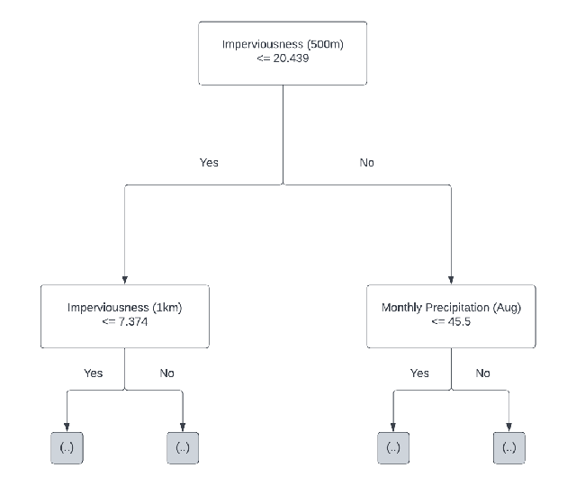 The forest's opening move: is more than ~20% of the surrounding 500 m paved?
That's not a fluke of one tree. Across the whole binary model, the four imperviousness radii soak up 62% of the total feature importance, with regional economics a distant second and precipitation barely registering:
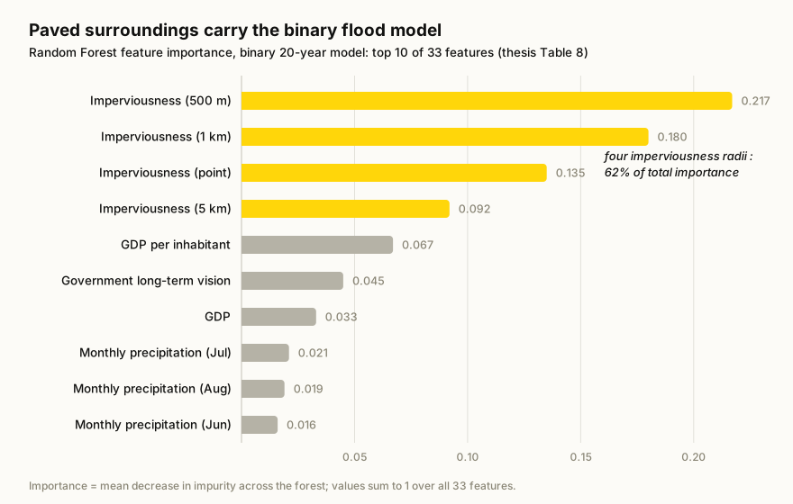 Feature importances for the binary model (thesis Table 8): paved surroundings carry the prediction, for a reason explained below.
In the multi-class models, relative height to the surrounding terrain joins as the second big family. Read the imperviousness result with care, however. In the binary model, more paved surroundings point to no flood, and the thesis warns why: imperviousness is only defined around cities, which is where most of the no-flood samples sit. Much of this signal therefore reflects how the sample was built rather than hydrology. What holds is that the model can show its reasoning per asset.
Why this matters (and where it stops)
The payoff is a screening layer that's explainable by construction. Every asset gets not just a flood class but the local factors driving it, and the inputs can be refreshed as land cover changes, something a frozen simulation output will never do. I'm equally upfront about the limits: the simulation is treated as ground truth, accuracy is the only reported metric, and the no-flood sampling is a flaw the thesis itself calls out: it may explain the imperviousness result and part of the 97%. It was a BSc thesis, not a product. But it convinced me that "explain, don't just simulate" is a viable stance for geospatial risk.
Written with AI, checked by me.
Back to projects